Blink and its gone – spectacular time-lapse of ice retreat at Fox Glacier

This spectacular time-lapse video ((Created by Victoria University of Wellington with the support of Fox Glacier Guides, Department of Conservation, Snowgrass Solutions, University of Canterbury and the Marsden Fund.)) captures the dramatic retreat of the Fox Glacier in Westland over the last year — 300 metres between January 2015 and January this year. As the ice retreats, the hillside becomes unstable and collapses down into the valley. To get a sense of the scale, you can see people watching from a safe point on the bottom right.

The rapid retreat of both Fox and its neighbour Franz Josef has led to the abandonment of guided walks on the glacier tongues. The ice is now only accessible by helicopter on to the upper reaches.

The collapse of the walls of the valley at Fox (as well as rocks and sediment transported by the ice) has caused the valley floor to rise by a metre over the last two years, as measured by Massey University scientists (see also NZ Herald). They’ve also photographed the retreat over the last decade, but the most marked loss seems to be in the last few years.

NZ’s west coast glaciers are amongst the most dynamic in the world, fed by huge snowfalls in their nevées under Mt Cook — as much as 6 metres a year in the snowfield feeding the Franz-Josef, as Mauri Pelto notes here. At the moment, ice melt in the tongues of both glaciers is outpacing the ice input above, and so the glaciers are retreating fast, but a run of years with heavy snowfalls could reverse the process — at least temporarily.

New Zealand’s Southern Alps have lost a third of their ice

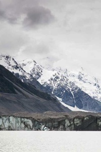
This article by Jim Salinger, University of Auckland; Blair Fitzharris, University of Otago, and Trevor Chinn, National Institute of Water and Atmospheric Research, was first published at The Conversation. The photo at left shows the calving face of the Tasman Glacier in Dec 2013.

A third of the permanent snow and ice of New Zealand’s Southern Alps has now disappeared, according to our new research based on National Institute of Water and Atmospheric Research aerial surveys. Since 1977, the Southern Alps’ ice volume has shrunk by 18.4 km3 or 34%, and those ice losses have been accelerating rapidly in the past 15 years.

The story of the Southern Alps’s disappearing ice has been very dramatic – and when lined up with rapid glacier retreats in many parts of the world, raises serious questions about future sea level rise and coastal climate impacts.

The Southern Alps’ total ice volume (solid line) and annual gains or losses (bars) from 1976 to 2014 in km3 of water equivalent, as calculated from the end-of-summer-snowline monitoring programme. Continue reading “New Zealand’s Southern Alps have lost a third of their ice”

Messages from a sizzling continent: Salinger on the Aussie heatwave

This op-ed by climate scientist Jim Salinger first appeared in print editions of the New Zealand Herald last Tuesday.
Global warming is not a phenomenon for future generations to deal with: it has arrived. And more frequent heat waves and climate extremes are part of this phenomenon. As I watch from my summer roost in northern New South Wales, the somewhat unprecedented heat is searing the Australian continent making it tinder dry with fires springing up everywhere. These raise some pertinent lessons on climate and risk management for New Zealand.

Firstly let’s look at some figures and ask the question of what are the climate mechanisms behind the heat waves.

Continue reading “Messages from a sizzling continent: Salinger on the Aussie heatwave”

Bad news but great pictures: dating NZ’s shrinking glaciers shows strong link between ice loss and CO2 increases

Here’s a superb video from the Department of Education at the American Museum of Natural History, showing how NZ and US scientists are examining the precise timing of glacier advances and retreats in the Mackenzie country around Lake Pukaki using surface exposure dating. Like all good geologists they use big hammers and small explosives to shatter rocks in order to sample “cosmogenic” Be-10 — a beryllium isotope formed when cosmic rays hit quartz in newly exposed rocks. See here for more on recent surface exposure dating work in the Pukaki area. Hat tip to Climate Crocks for spotting the video.

Greenland’s extraordinary summer: melting records and ice island setting sail

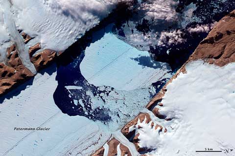
Petermann2012203

July has been an amazing month in Greenland. The Petermann Glacier has given birth to another huge ice island — taking its terminus further back up its fjord than at any time in the last 100 years (at least), record high temperatures have been recorded at the summit of the ice sheet at 3,200 meters, initiating surface melt over the whole vast sheet, ice sheet albedo has plummeted, and the Jakobshavn Isbrae’s calving front has retreated into the ice sheet.

The best coverage of the Petermann event, as on most matters to do with the Arctic summer and sea ice melting season is to be found at Neven’s Arctic Sea Ice blog. It’s well worth reading the comments under the Petermann post there, to get a really informative picture of what’s being going on. Here’s a description by Dr Andreas Muenchow ((Andreas provides great coverage of the Petermann glacier at his blog — perhaps unsurprisingly, as he’s on his way up there to recover instrumentation soon.)) of what the calving would have been like:

I described the Petermann calving to some media folks as a gentle and very quiet affair similar to a rubber duckie pushed out to sea from the deck of a flat pool.

Some duckie, some pool…

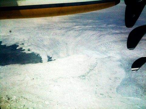
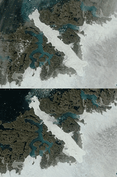
Illulisatanimated2012203Further south, the the “root” of the Jakobshavn Isbrae has enlarged significantly, with the calving front of Greenland’s most productive glacier retreating further into the ice sheet. The “blink” image I’ve cobbled together (left) shows day 203 of this year compared with day 202 of last year ((Source: 2012, 2011.)). The difference is large and very obvious. Greenland specialist Dr Jason Box was flying out of Ilulisat shortly after the retreat earlier this month, and snapped the photo below out of the window of his plane. As he commented on Facebook, it looks like the glacier has divided into two streams.

BoxGreenlandIllulisat

Up at the summit of the Greenland ice sheet at 3,200 metres, a new high temperature record of 3.6ºC was set on July 16, hard on the heels of four days in row of temperatures above freezing, from July 11 to 14. Considering that temperatures above zero had only been recorded four times in the preceding 12 years, this amounted a remarkable heatwave, and triggered an astonishing melt record.

Greenlandmelt2012

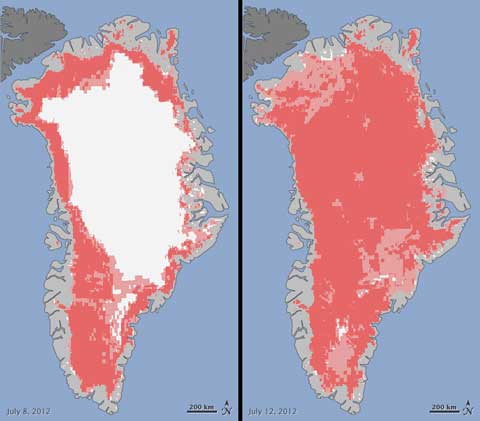
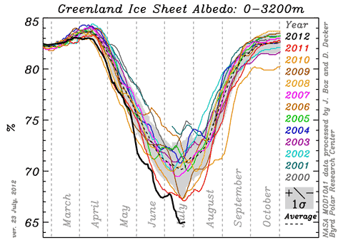
This NASA graphic shows how the melting surface, shown in shades of red, spread over the whole surface of the ice sheet from July 8 to July 12. This amounts to “the largest extent of surface melting observed in three decades of satellite observations”, according to NASA. The last such melting event occurred in 1889, and ice cores show that they occur every 150 to 250 years. However, given the steady increase in melt area over the last decade, and the precipitous drop in ice sheet albedo (see below), especially at high altitudes, it may not be 150 years before such a melt happens again.

GISalbedo201207

The last time I looked at this extraordinary summer in Greenland, it was to report Jason Box‘s view that “it is reasonable to expect 100% melt area over the ice sheet within another similar decade of warming”. It took two weeks to come true. Forgive me if I find that alarming.