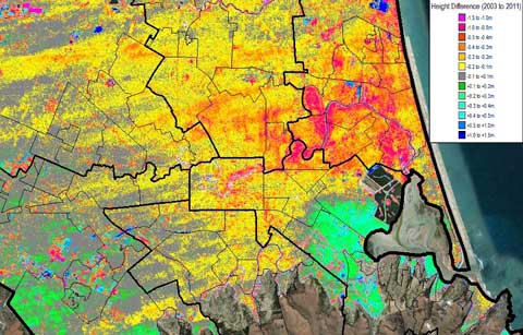
The first major study to look at the impact of sea level rise on Christchurch and Banks Peninsula following the 2010/11 earthquake sequence projects a watery future for many parts of the city and its surrounding shorelines. The image above ((Fig 3-4, p15 in the report.)) shows changes in ground elevation between 2003 and 2011 in the Christchurch region. Areas in green/blue have moved upwards by half a metre – particularly noticeable to the west of the estuary – and areas in red and yellow down, in many places along the Avon and subsidiary streams by a metre or more.
The report, Effects of Sea Level Rise on Christchurch City (pdf), by consultants Tonkin & Taylor was released last week and suggests that as a minimum planners should take into account a 1m rise in sea level over the next 100 years. Combined with the elevations changes caused by the earthquakes, this would mean significant shoreline retreats, increased flooding in many areas and the loss of hundreds of hectares of land to the sea. It’s well worth digging into the report to get the full picture, and it will make uncomfortable reading for many in the city.
Tonkin & Taylor prepared their study before the IPCC’s AR5 Working Group One report was released, and so based their SLR numbers on a literature search and the Royal Society of NZ’s 2010 paper. They suggest a “plausible upper range” of 2m over the next 100 years, with the behaviour of the West Antarctic and Greenland ice sheets in a warming world “probably the largest uncertainty in sea level rise projections”.
And now the bad news…
Continue reading “Sea level rise, earthquakes, and flying PIGs”

 It’s only if we fail to grasp the enormity of the threatened impacts of climate change on the global environment that we can scoff at the notion that even volcanic eruptions and earthquakes may be triggered as a consequence of our continuing to burn fossil fuels. Not that it’s an easy consequence to appreciate, but vulcanologist
  This weekend a few of the struggling residents of earthquake-hit Christchurch have