
This animation shows Greenland’s ice mass loss over 2003 to 2009, estimated by combining data from NASA’s GRACE satellites with high precision GPS measurements of “rebound” in the underlying rock as the weight of ice is removed. The lightest blue shows low levels of mass loss, black the highest. From the University of Colorado press release:
“Our results show that the ice loss, which has been well documented over southern portions of Greenland, is now spreading up along the northwest coast,” said Shfaqat Abbas Khan, lead author on a paper that will appear in Geophysical Research Letters.
Khan goes on to suggest what this might imply for the future:
If this activity in northwest Greenland continues and really accelerates some of the major glaciers in the area — like the Humboldt Glacier and the Peterman Glacier — Greenland’s total ice loss could easily be increased by an additional 50 to 100 cubic kilometers (12 to 24 cubic miles) within a few years.
Another good reason to keep an eye on the Arctic this summer. Climate Progress has a very good overview of recent work on Greenland ice loss and its implications for sea level rise. Well worth a read, if not exactly comforting.
 The Copenhagen climate conference (
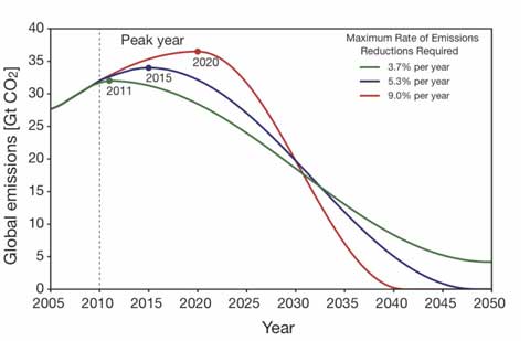
 Sea level will rise by more than a metre by 2100 according to the authors of the third chapter in the World Wide Fund for Nature’s new Arctic report,