This is hardcore

WarmWAIS.jpg 
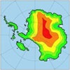
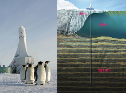
The last time that atmospheric CO2 levels were as high as today, the West Antarctic Ice Sheet (WAIS) regularly retreated or collapsed, causing sea level rises of up to 7 metres according to the first analysis of the first ANDRILL core, published in Nature today. The ANDRILL (Antarctic Geological Drilling) programme, a joint effort by scientists from New Zealand, Italy, the USA and Germany, drilled a 1,280 metre core from the seabed under the Ross Ice Shelf. It’s the longest and most complete drill core recovered from Antarctica, and was made possible by drilling technology developed by a team at the Antarctic Research Centre at Victoria University of Wellington led by Alex Pyne.

Andrill.jpg

The two Nature papers [1. Obliquity-paced Pliocene West Antarctic ice sheet oscillations, Naish et al, Nature, 19 March 2009 doi:10.1038/nature07867, and Modelling West Antarctic ice sheet growth and collapse through the past five million years, Pollard and DeConto, doi:10.1038/nature07809] focus on the “warm Pliocene” between two and five million years ago when CO2 levels were around 400 ppm. This is considered a good analogue for where our climate is headed, and the consequence, according to Professor Tim Naish of VUW, joint science head of ANDRILL, is that if we reach 550 ppm CO2 and a resulting 3ºC increase in global temperature, then large parts of the WAIS could melt on timescales of the order of centuries, and be completely gone within a thousand years.

The ANDRILL core documents 38 advances and retreats of the ice sheet, and suggests that during the warm Pliocene the key driver could have been the “obliquity” cycle in the earth’s orbit around the sun — a 40,000 year tilt in the Earth’s axis towards and away from the sun that affects the length of summers at the poles. New modelling of the ice sheet[2. Pollard & DeConto] confirms the link with the obliquity cycle, and suggests that the primary mechanism is melting of the base of the ice sheet by warm oceanic waters — a process that has already started.

In other WAIS news, a British team reports on the success of their robot submarine, Autosub, which made voyages of up to 110km under the Pine Island Glacier ice shelf, recording temperature and salinity, and providing valuable data about melting at the glacier grounding line.

More coverage: Nature commentary by Phillipe Huybrechts, Science Daily, the Telegraph, AP and Reuters.

[Pulp]

Down down

New Scientist has posted this remarkable footage of a camera being lowered down a moulin in Greenland, and reveals that Konrad Steffen’s team, moulin explorers extraordinaire, are inventing a new extreme sport:

Later this year, the team will be boldly going where no researchers have gone before. Under the guidance of expert climbers, they plan to descend deep into a moulin in person. They will leave temperature and flow sensors along the way, so they can track how the tunnel changes throughout the year.

Steffen’s team also released hundreds of special rubber ducks into moulins, but none have yet appeared at the edge of the ice sheet. He fears they may have been ground to pieces by the moving ice. More at the Guardian.

[Quo]

Flying high

MarionArawata.jpgNZ glacier experts are flying round the Alps at the moment shooting glaciers (with cameras and GPS units), conducting their annual ice mass balance audit. TV One sent a reporter to see what Trevor Chinn and Jim Salinger were up to, and on Sunday broadcast a nice little item about the process. Highlights: Jim Salinger rolls out his new favourite measure of volume, the Rangitoto, and Trevor Chinn can be heard commenting “They’ve bloody wrecked a glacier”… Last year’s survey results here, with link to background article.

[Country Joe]

Reelin’ in the year

IPYWMO.jpg The International Polar Year (IPY) 2007-8 formally draws to a close today, and when today arrives in Geneva there will be a press conference to mark the release of a summary report, The State of Polar Research [PDF], which covers some of the preliminary findings. [BBC report here]. In the run up to this event, there’s been a blizzard (…sorry) of stories from the teams working at both ends of the world, and they make fascinating reading. From huge pools of freshwater building up in the Arctic Ocean to new mountain ranges as big as the Alps under Antarctica, methane plumes off Siberia and the death knell for summer sea ice in the Arctic, there’s a lot to cover…

Continue reading “Reelin’ in the year”

Five feet high and rising!

Sea.jpg Yesterday, while dissembling, I had what I might loosely describe as a “bugger” moment. Yale’s Enviroment360 web site (which I plugged on its introduction last June) currently features an interview with Robert Bindschadler, a NASA ice expert who is working on the Pine Island and Thwaites glaciers in West Antarctica. The “bugger” moment?

e360: And in the theoretical case that Pine Island and Thwaites glaciers completely dump into the ocean – obviously it’s not going to happen in the near-future – what kind of sea level rise would they contribute to?

Bindschadler: That portion of West Antarctica, that third that flows northward primarily through those two glaciers, has the potential to raise sea level 1½ meters. That’s sort of an upper bound, a worst case. But the time scale is what really matters. Some say that we won’t see these ice shelves disappear in our lifetime – I’m not so sure. I think we might well.

e360: Are you kidding?

Bindschadler: No, no at all.

Bindschadler looks to be about my age. He reports that the ice shelf is melting from the underneath at a rate of about 50 metres per year at the grounding line. And then, a little later, just to make me spill my tea on the keyboard:

e360: I know that the IPCC was saying maybe 1 ½ feet or a half-meter of sea level rise in the 21st century. Is it your opinion that we could be looking at significantly larger sea level rise?

Bindschadler: Yeah, I think there’s sort of an unspoken consensus in my community that if you want to look at the very largest number in the IPCC report, they said 58 centimeters, so almost two feet by the end of the century. That’s way low, and it’s going to be well over a meter. We may see a meter by the middle of the century.

e360: Oh my gosh.

Bindschadler: And if this behavior that we’re seeing in Pine Island, and even Greenland continues – and we don’t see any reason why it wouldn’t continue – well, over a meter by the end of the century, I think is almost certain.

How notably prim the interviewer is. I think I might have managed something a little more Anglo Saxon. A “meter by the middle of the century” is a very long way above most people’s worst case (though not, perhaps, Hansen’s), but it makes our vulnerability to sea level rise much more of a near-term danger than a comfortable reading of AR4 might suggest. It’s a fascinating article — goes into more detail about the WA ice sheet and PIG (yes, that’s what they call it) than anything else I’ve seen in the last few years. Recommended, but not if you have beachfront property.

Meanwhile, a workshop being held at VUW in Wellington is looking at Andrill results, and finding that the WA ice sheet shows signs of repeated meltbacks over the last five million years [Stuff]:

Professor Tim Naish, director of Victoria University’s Antarctic Research Centre […] is co-science leader of the $30 million Andrill project on the ice, with Professor Ross Powell from Northern Illinois University in the United States.

“Antarctica’s ice sheets have grown and collapsed at least 40 times over the past five million years,” Prof Naish said.

“The story we are telling is around the history and behaviour of the ice sheet … as an analogue for the future,” he said.

Not good news, it seems. Expect a rush of papers covering Andrill work over the next few months.

[Johnny Cash]