
 Blogs, or to spell out the contraction, web logs, were originally just that: a log of interesting things found on the internet. Yesterday was a day when I rediscovered that tradition. Prompted by a comment from glaciologist Mauri Pelto on my recent Greenland post, I started off by making a visit to NASA’s MODIS Rapid Response System image site, which provides access to near real-time imagery from the Aqua and Terra satellites (click on Near-real-time production under “quick links” to be taken to the most recent images). The images aren’t fully processed (you can see “stripes” and slight distortions), but they give you a good look at what’s going on. I first went and had a look at what spring on the Petermann glacier in NW Greenland looked like:

The dark area running left to right is open water (with skiffs of ice) in the Nares Strait between Ellesmere Island (top) and Greenland (bottom). The ball shape on the right is open water in the Lincoln Sea, where pack ice is breaking up and heading south through the strait. The Petermann flows upwards into Nares Strait a little to the right of centre. If you click on the image and look at the full version on the NASA site at 250m resolution (caution, big file), you can see a lot of detail on the glacier tongue, including the rifts Mauri discusses in his post on the subject at From A Glacier’s Perspective. Compare that view with the sea ice map from the University of Bremen’s web site. The thumbnail at the top of the post shows how that open water showed up yesterday — a thin yellow line. But when you look at the ice at higher resolution in the visual spectrum you see something much more dramatic: open water with sea ice being exported from the Arctic ocean.
So far so good. That I’m a sucker for pretty pictures from space is not news. But I recalled that over at µWatts they’d begun their regular spring effort to make fun of the Catlin Ice Survey, and so I hopped over to the Survey’s rather good web site. The Catlin team are hauling sledges towards the pole, taking lots of ice measurements as they go. This blog item struck me as interesting:
Our Explorer Team have reported another day of walking on ‘flippy floppy ice’, the likes of which none of them have experienced, despite clocking up years of Polar Travel between them.
This ultra-thin, bendy ice is created when great expanses of open water refreeze, and that which our team is gingerly making their way across is often no more than a few days old.
“The conditions we’re experiencing are unlike anything I’ve seen in any of the nineteen expeditions I’ve previously been on,” says Martin Hartley. “There are great swathes of only recently refrozen open water peppered with small snow-covered islands of ice in the distance. I wonder if this is a sign of things to come for Arctic travel?”
That prompted to me to see if I could get some MODIS imagery of the team’s position. It’s not easy from the raw product to work out exactly what you’re looking at, but then I found this wonderful Arctic mosaic: images from the Terra satellite stitched together to give a view of the Arctic as it was on March 27th , from high above the North Pole.
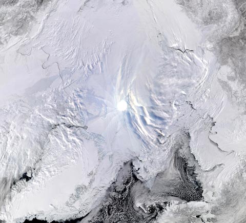
Click on the image to get to the full size 1 km resolution image. It’s a big file, but worth every byte. It is a thing of great beauty. There’s not much cloud around at the top of the world, and most of the sea ice is exposed to view. Find Nares Strait and scroll upwards. There are great cracks in the pack ice, some dark and new, others grey and obviously recently frozen over. It looks as though the Catlin team are somewhere in the middle of all that cracked ice, and I don’t envy them one bit… [To get other mosaics click on “Arctic mosaics” under “quick links” on the MODIS front page, but you may have to page back to earlier days to get full pictures. The Antarctica mosaics are also stunning.]
For the Arctic tourist from space there’s a huge amount to see in this image: cloud streets curving south round the top of Svalbard, new sea ice forming frappucino swirls off Novaya Zemlya, and between Svalbard and Greenland plates of pack ice crack and refreeze together as they exit the Arctic Basin. If nothing else, it shows just how mobile the sea ice is, and how extensively it’s fractured. You can quantify that mobility by looking at the tracks of the International Arctic Buoy Programme (here), or by looking at the reports from the Catlin ice team. They’re slaving away towards the pole, but the ice is moving them away. Some days they get precisely nowhere.
So what’s really going on up North? Should I be betting on a new record minimum this year? Andy Revkin at DotEarth recently suggested that the winter weather patterns were conducive to ice build-up, despite warmth over northeast Canada and Greenland. William “Stoat” Connolley deems it unlikely he’ll be betting this year, preferring to stick with his $1,000 bet with Joe Romm against 90% loss by 2020. On the other hand, my peregrinations around the imagery confirm my view that the key to the current situation is not the extent (or area) of the ice, it’s the volume. As the Catlin team reports, some of the stuff that contributes to the figures is only a few centimetres thick. There should be some new numbers on ice volume from Ron Kwok’s team at NASA in the next couple of months, and the SEARCH forecasting exercise is being repeated this year, so more data will soon be available. In the meantime, I’m not going to bet against a new record, but reserve the right not to bet at all. And now I have a hedge to trim… 😉
Finally, and in the spirit of traditional blogging, here’s something I missed when it first came out — an article by Johann Hari at The Economist‘s Intelligent Life magazine describing a visit to Greenland last year. His description of the Inuit response to warming is compelling.
Compare the Nares Strait this year to 2009 http://bprc.osu.edu/MODIS/?p=57 analayzed by Jason Box Also if you look at the ice along the northern margin of the Petermann in particular in summer imagery you will see that there is a section of unconsolidated junk ice between the cohesive ice of the glacier and the fjord margin. The fjord wall is then not a pinning point. This junk ice fringe can be seen up to 30 km upglacier. http://glacierchange.wordpress.com/2010/03/27/pet… Petermann Post
Cheers for the links Gareth & Mauri, some awesome imagery.
thanks for the images. presumably the cracking of the ice is slowing down the drop in the extent.