[youtube]UaKqhRTqSlg[/youtube]
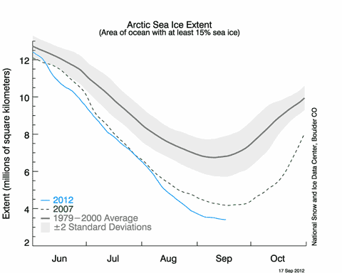
According to the latest bulletin from the National Snow and Ice Data Center in the US, Arctic sea ice is likely to be at or about its minimum extent for the summer (as of Sept 17th). The animation above shows how the ice melt proceeded through the summer (up to Sept 14th), and the graph below shows the extent as of Sept 17th — 3.41 million square kilometres (1.32 million square miles).

The NSIDC notes:
The current extent is 760,000 square kilometres (293,000 square miles) below the previous record minimum extent in the satellite record (4.17 million square kilometres or 1.61 million square miles) which occurred on September 18, 2007. This difference is larger than the size of the state of Texas. The ice extent currently tracks nearly 50% below the 1979 to 2000 average minimum extent.
For an insight into what the ice is really like, I recommend Julienne Stroeve’s blog of her trip on the Greenpeace vessel Arctic Sunrise. This is from her most recent entry (Sept 17th):
