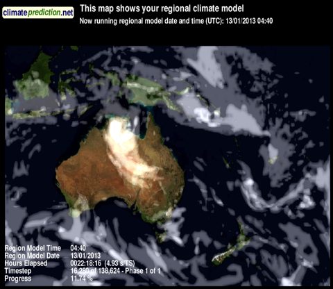
Climate modelling on your PC: weather@home comes to NZ and Australia

Climateprediction

That’s a climate model running on my iMac, thanks to BOINC, Climateprediction.net, and the new New Zealand and Australia modelling experiment launched yesterday. In this guest post, Dr Suzanne Rosier of NIWA explains what it’s all about…

A new citizen science experiment in which scientists will address possible links between climate change and extreme weather in Australia and New Zealand was launched on Wednesday. Weather@home ANZ runs as part of the highly successful climateprediction.net project based at the University of Oxford, which makes state-of-the-art climate models available for anyone with a PC and an Internet connection to download and run on their computer. The global model contains within it a much more detailed model of the Australia/New Zealand region, detailed enough to model weather events properly, and the ‘2-in-1’ model needs to be run many thousands of times if scientists are to have a chance of capturing the very rarest weather events. This takes a huge amount of computing power – and you can help by volunteering your computer.

The model runs in the background on your machine, taking up any processing power that happens to be spare, but not interfering with your work. When your computer has finished crunching the results are automatically uploaded to a server at the University of Tasmania. If you take part in the project you also have the option to see how the model you are running on your machine is progressing. Many thousands of generous volunteers have already taken part in climateprediction.net, running global models, and Weather@home, running regional models for other parts of the world. This is your chance to get involved and help scientists to gain a better understanding of what is happening to weather in Australia and New Zealand region as the climate changes.

The experiment launched today will produce many thousands of different simulations of how the weather in 2013 might have been, both with and without anthropogenic greenhouse gas emissions. This will enable scientists to put some hard numbers on how the risks of extreme weather events might — or might not — be changing as a result of the human contribution to global climate change. Scientists at NIWA will focus initially on the severe North Island drought of January to March 2013, but later the record-breaking warmth of last year’s winter will also come under scrutiny. Extreme rainfall events, such as that in Golden Bay and Nelson in December 2011 and the recent floods in Christchurch, will also be investigated as the Weather@home ANZ experiment continues.
The more people who participate, the more science can be done. Please go to ‘weatherathome.net’ – sign up, and start crunching numbers.

Gareth adds: Suzanne does an excellent job of introducing the project in this video:

Read more about the project at Climateprediction.net, The Conversation, and NIWA. If anyone’s interested in running an NZ climate team, let me know. For some background to the difficult statistics of extreme weather events, I highly recommend this recent article by Stefan Rahmstorf at RealClimate. The Weather@home ANZ models will run (via BOINC, the framework for distributed processing developed at Berkeley and used in a wide variety of distributed computing projects such as Seti@home or Folding@home) on most recent releases of Windows, Mac OSX and Linux.

Where the wind blows, it rains: Arctic warming and wacky jetstream ruins European summers

The dramatic loss of summer sea ice in the Arctic has prompted a lot of research interest in the way that this is affecting weather patterns around the northern hemisphere. The latest contribution is Influence of Arctic sea ice on European summer precipitation, by Dr James Screen of the University of Exeter [PhysOrg]. In this “video abstract”, he explains how reductions in Arctic sea ice affect the position of jetstream — the ribbon of winds winding around the planet that guides weather systems — bringing more summer storms to Western Europe, and a recent run of record-setting wet summers to the UK. But as he points out, the effects are planet-wide:

The impacts are not just over northwest Europe. Actually in the model, what we find is that whilst the sea ice loss increases rainfall over northwest Europe, we actually find drier conditions over Mediterranean Europe. Also the jet steam shifts over North America, which can have implications for the weather there too.

Dr Screen’s study underlines a point that I have been making for some time: rapid climate change is not something theoretical that will happen in the future — it’s happening now and we’re feeling the effects. Warming in the Arctic is driving sea ice loss, and the atmospheric consequences are changing the shape of the weather right round the northern half of the planet.

Also interesting, and also looking at jetstream patterns is Probability of US heat waves affected by a subseasonal planetary wave pattern, in which the authors find that US heatwaves might be predictable 15-20 days earlier than at present by monitoring a particular jetstream wave pattern. [Science Daily]

It’s worth noting that an especially vigorous jetstream directed and helped to intensify the recent huge European storm that hammered the UK, Germany and Denmark, killing 16 people and causing huge amounts of damage. Christopher Burt at WeatherUnderground provides a handy overview of the storm that has four names — St Jude, Christian, Simone and Carmen. The storm centre moved 2,000 km in 26 hours, a remarkable pace of 77 kph.

Why is Federated Farmers promoting climate denial during a major drought?

The man who believes Obama's birth certificate was faked, promoted by Federated Farmers.
The man who believes Obama’s birth certificate was faked, promoted by Federated Farmers.

You’d think, in the middle of the worst drought in 70 years, with farmers in crisis, that their national political body might be thinking about  the big picture of climate change and how best to communicate that to farmers.

In Marlborough, where the drought is hitting hard, the local Federated Farmers chapter is sponsoring a talk by crank Lord Monckton.   I asked Conor English, Federated Farmers CEO,  what he thought about this and he said:

“We have 24 Provinces and they get all sorts of speakers on all sorts of things. We simply don’t know.”

OK, one renegade chapter. Fair enough. I’m sure Top of the South farmers will be relieved to know climate change isn’t real.

But on March 8, Federated Farmers’ “Friday Flash” weekly email bulletin was mailed to members right around the country, including a full-on promotion, with dates, links, and phone numbers of Monckton’s wander around the country.  The item even questioned the science of global warming, running out the tired old denier “global warming has stalled for 16 years” argument (rebutted here) that is central to Monckton’s theories.

So I went back to Mr English to ask how they could be promoting Monckton’s visit, right in the middle of this terrible drought, the type of  drought farmers are expected to get a lot more of as climate impacts kick in. Continue reading “Why is Federated Farmers promoting climate denial during a major drought?”

Prat watch #9: Ring’s wrong again

New Zealand’s favourite astrologer, the self-appointed “long range weather forecaster” Ken Ring — who is wrong about everything — has not been having a good start to the year. He’s having trouble reconciling NZ’s record drought with the forecasts he’s been making. Here’s Ring on February 26th, in an opinion piece headlined Hang on farmers, rain is coming, published at Yahoo News:

So the question being asked is whether or not a drought is imminent. The answer is no.

Compare and contrast with this news report from Friday last (March 15th):

The entire North Island has been declared a drought zone this morning.

Every time anyone other than Ring takes a look at his forecasts, they are found to be useless ((In January, the Greymouth Star noted:

Self-proclaimed weather guru Ken Ring is wildly astray in his January predictions for the South Island hydro lakes region, in his 2013 weather almanac. His summary for January, based on lunar patterns, says “the driest regions for the South Island for January may be the hydro lakes”.

But Environment Canterbury flood controller Tony Henderson said the 500mm of rain in the Waitaki and Rangitata river catchments over four days was “probably the most we’ve had over the summer in several decades”.

)). But Ring is working hard to rewrite history to his advantage. His Yahoo News column was posted on Feb 26th, but the same article seems to have been posted to his website a few days earlier ((The datestamp says Feb 22nd.)). He’s revisited the piece, and added some notes in red attempting to justify his failed forecasts. But there’s one other change he’s made. Here it is:

So the question being asked is whether or not a lingering drought is imminent. The answer is no.

Of such little dishonesties are Ring successes made. He remains a charlatan, and is — as ever — wrong about everything.

Bill English’s weasel words on weather, climate and drought

Occasionally — but only occasionally — the political pantomime that is parliamentary question time throws up something interesting. Yesterday, NZ’s deputy prime minister Bill English managed to dig himself into a drought-ridden hole, only to emerge looking like a climate denier. Green Party co-leader Russel Norman tried to get English to expand on his earlier comments that the government would not be able to help farmers hit by increased incidence of droughts, which led to this astonishing little exchange [Hansard transcript here]:

Dr Russel Norman: Does he agree with the Government’s own research body the National Institute of Water and Atmospheric Research (NIWA) when it states: “Droughts are projected to become more frequent and more intense under climate change.”?

Hon Bill English: I would not want to question the scientific effort that has gone into that, although there is always uncertainty about these predictions. I recall similar predictions made by similar scientific bodies in Australia just 4 or 5 years ago and it has not stopped raining since.

Astonishing stuff. English gets the uncertainty issue completely wrong ((The best evidence (NIWA summary pdf here) we have indicates that the frequency of droughts is going to increase — the uncertainty is by how much and when.)), and then manages to insult Australians who have been suffering through their hottest summer ever. Here’s a little chart from the Aussie Climate Commission that he might find helpful.

Continue reading “Bill English’s weasel words on weather, climate and drought”