
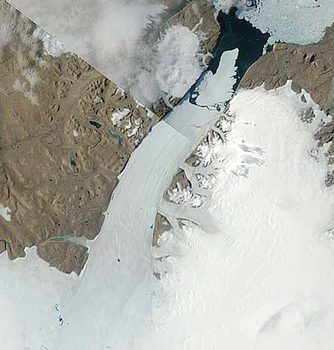
The Petermann Glacier in northwest Greenland has calved a massive “ice island” from its floating tongue (the largest in northern hemisphere), as the MODIS image above demonstrates. The island is approximately 260 square kilometers in area, making it equivalent to (arbitrary choice of geographical comparison appropriate to blog) eleven Rangitoto Islands (or four Manhattans, or about one eightieth of the area of Wales), and broke off at the end of last week. It contains enough fresh water (being nearly 200m thick) to keep the USA supplied with tap water for 120 days. NOAA’s National Ice Centre provides another view, with the ice island outlined in red:

University of Delaware researcher Andreas Muenchow describes its likely future thus:
“In Nares Strait, the ice island will encounter real islands that are all much smaller in size,” Muenchow said. “The newly born ice-island may become land-fast, block the channel, or it may break into smaller pieces as it is propelled south by the prevailing ocean currents. From there, it will likely follow along the coasts of Baffin Island and Labrador, to reach the Atlantic within the next two years.”
I’ve been watching the area in the daily MODIS Arctic mosaic imagery, half expecting to see a calving event (based on Mauri Pelto’s comments), but persistent cloud cover (and my lack of persistence) meant that Science2.0 blogger and Arctic watcher Patrick Lockerby was the first person to spot the big berg — something he’d forecast back in July. Congratulations, Patrick. It’ll be interesting to see what happens to the ice front over the next few weeks, and where the island heads. My own tip? I’ve got my suspicions about the Humboldt glacier to the west of the Petermann…
See also: Climate Progress, BBC, Guardian, earlier HT posts.
[Tunng]
What happened to cause the last even bigger ice island back in ’62?
It calves icebergs regularly — it’s a major outlet glacier for the Greenland ice sheet — and occasionally very large ones. So this event is not necessarily unprecedented, but it is unusual. However, surface melt in this part of the island (see all the blue bits up the glacier?) is a relatively recent phenomenon, if I recall correctly.
Hey Garth,
Have you seen this good news about renewable energy use from Portugal?
http://www.nytimes.com/2010/08/10/science/earth/10portugal.html?_r=1&hpw=&pagewanted=all
Cheers,
Leapy
Thanks, Leapy. Interesting.
The article about Portugal suggests that their renewables percentage will go from 17% in 2005 to 45% in 2010. According to the IEA the 17% figure in 2005 is an abberation because hydro only contributed 10% of the GWh used when it normally contributes about 20%. The figures for renewables as a % of Electricity generation were 2005 (17.9%), 2006 (32.4%), 2007 (34.6%) 2008 (32.2%) and 2009 est (37.1%). Wind has increased from 3.8% in 2005 to 15.4% in 2009, which is excellent progress, but not quite the miracle implied by the article in the NY Times.
For an alternative view on the rate of transition to renewables see this book review at The Oil Drum.
And the US Govt can’t say they don’t know about it or its consequences:
http://www.guardian.co.uk/environment/2010/aug/10/greenland-ice-sheet-tipping-point
Gareth,
You’re not kidding its unusual – don’t be mislead by the 1962 reference. The two events are not comparable – the 1962 ice island came from the break up of an ice shelf, no from a glacier.
A century ago, Ellesmere Island had an 9000 sq km ice shelf on its northern side formed from a mix of glacial ice flowing off the island, and sea ice crushed up against the island by prevailing currents and winds. This shelf had been in existence for at least 3000 years. In the last 100 years, over 90 percent of that ice shelf has disintegrated. As it broke up, the fragments still attached to Ellesmere Island acquired their own names – in all seven smaller ice shelves were named, the largest of which is the Ward Hunt Ice Shelf.
Somewhere between August 1961 and April 1962 a combination of weather, tides and seismic activity caused a 600 sq km chunk to break off off the Ward Hunt Ice Shelf. Of the seven fragmentary Ice Shelves, three have now completely gone and Ward Hunt, the largest, is about 400 sq kms. (The proximate cause of the break might have been tides and seismic, but as to the underlying causes….well its not rocket science…)
So the phenomena are not very comparable – in Antarctica, the Ross Ice Shelf calves 1000 sq km ‘bergs fairly regularly. I’d be worried if a similar size chunk broke off the Pine Island Glacier….