Global sea ice in uncharted territory

The big heat of 2016 is taking its toll on sea ice at both poles

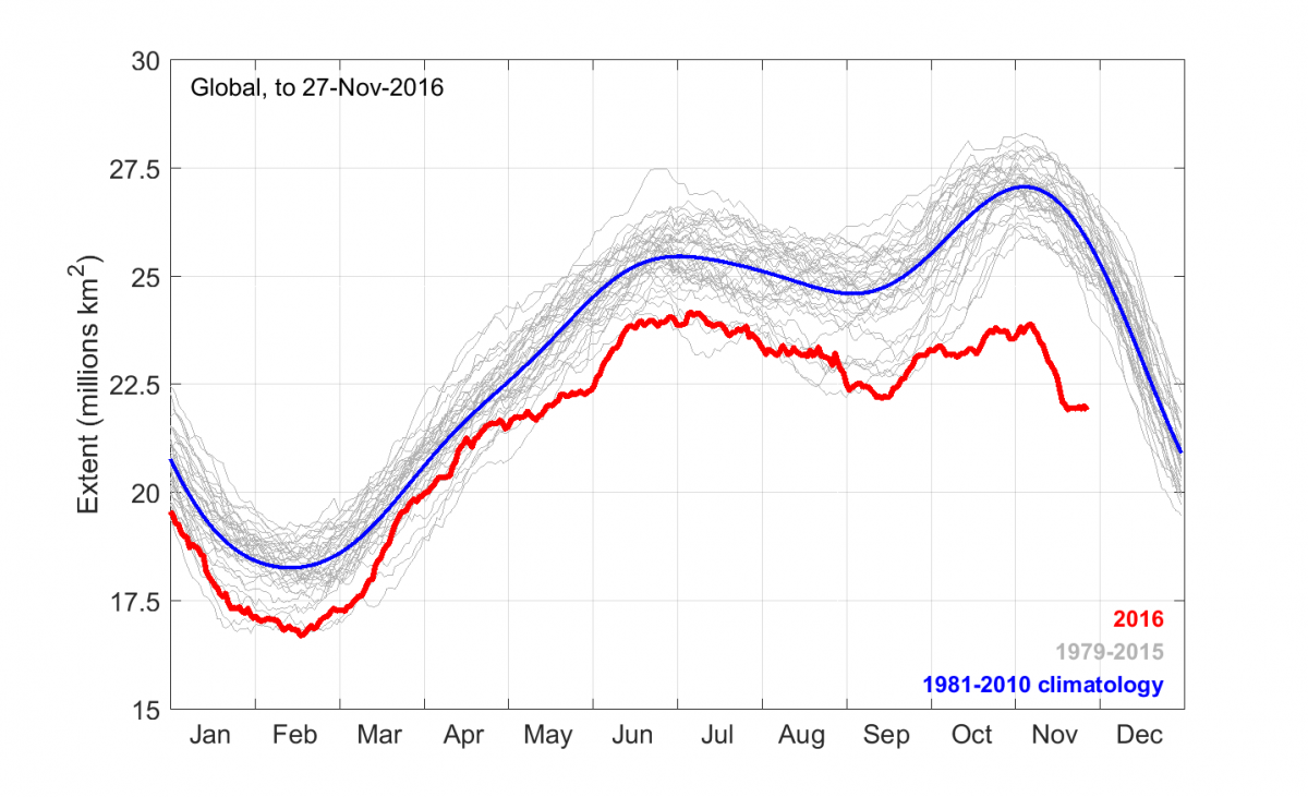
For the past couple of months, global sea ice extent (Arctic plus Antarctic) has been at record low levels. The way the northern and southern seasonal cycles add up, the maximum in global sea ice extent occurs on average in early November, at around 27 million km2. This year, the global extent curve has been relatively flat since June. In past years, climate change “deniers” have pointed to the global extent curve as a way of claiming that climate change is not a problem, as the relatively high Antarctic extent was partly offsetting the Arctic loss, making it look as though nothing much was changing. Strangely enough, we’ve heard nothing from the usual “deniers” this year! Through most of November, there has been around 4 million km2 less sea ice than normal globally (peaking at 4.5 million on 20 November), an area roughly the size of Greenland missing near each pole. What’s going on? Continue reading “Global sea ice in uncharted territory”

It’s grim up North (yet again)

The Arctic has had a warm winter and spring, and the heat is taking a toll on the sea ice…

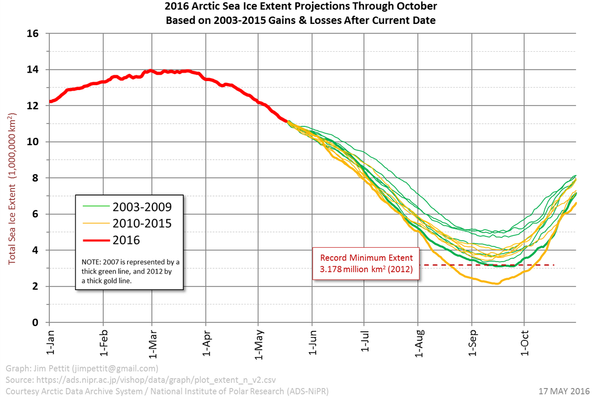
I find to my great shame that it’s three years since I last wrote much about the continuing and calamitous decline in Arctic sea ice. Back in the day, you could scarcely contain my enthusiasm for prognostications about the disappearance of the summer ice. But with the fantastic resource that is Neven’s Arctic Sea Ice blog covering the minutiae of every season, coverage from the other side of the world seems a little superfluous. On the other hand, the recent news is especially troubling… Continue reading “It’s grim up North (yet again)”

TDB Today: WACCy weather and a warm year

WACCyweather

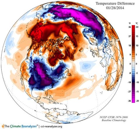
A classic case of WACCy weather in the northern hemisphere, seen here in a map from the excellent Climate Reanalyzer site, prompts me to discuss the 2013 global temperature numbers, the El Niño-Southern Oscillation, and what sea ice loss is doing to northern hemisphere weather patterns in my post at The Daily Blog this week. We live in interesting times…

Where the wind blows, it rains: Arctic warming and wacky jetstream ruins European summers

The dramatic loss of summer sea ice in the Arctic has prompted a lot of research interest in the way that this is affecting weather patterns around the northern hemisphere. The latest contribution is Influence of Arctic sea ice on European summer precipitation, by Dr James Screen of the University of Exeter [PhysOrg]. In this “video abstract”, he explains how reductions in Arctic sea ice affect the position of jetstream — the ribbon of winds winding around the planet that guides weather systems — bringing more summer storms to Western Europe, and a recent run of record-setting wet summers to the UK. But as he points out, the effects are planet-wide:

The impacts are not just over northwest Europe. Actually in the model, what we find is that whilst the sea ice loss increases rainfall over northwest Europe, we actually find drier conditions over Mediterranean Europe. Also the jet steam shifts over North America, which can have implications for the weather there too.

Dr Screen’s study underlines a point that I have been making for some time: rapid climate change is not something theoretical that will happen in the future — it’s happening now and we’re feeling the effects. Warming in the Arctic is driving sea ice loss, and the atmospheric consequences are changing the shape of the weather right round the northern half of the planet.

Also interesting, and also looking at jetstream patterns is Probability of US heat waves affected by a subseasonal planetary wave pattern, in which the authors find that US heatwaves might be predictable 15-20 days earlier than at present by monitoring a particular jetstream wave pattern. [Science Daily]

It’s worth noting that an especially vigorous jetstream directed and helped to intensify the recent huge European storm that hammered the UK, Germany and Denmark, killing 16 people and causing huge amounts of damage. Christopher Burt at WeatherUnderground provides a handy overview of the storm that has four names — St Jude, Christian, Simone and Carmen. The storm centre moved 2,000 km in 26 hours, a remarkable pace of 77 kph.

The Climate Show #35: elections, extremes and a big wind

We’re running a bit late with this one: recorded last week before the big wind left Gareth powerless for six days (a bit like Glenn’s PC), John Cook ruminates on the result of the Australian election, the boys marvel at the Mail’s myth making about Arctic sea ice, and look forward to the release of the first part of the next IPCC report. And much, much more. Show notes below the fold…

Watch The Climate Show on our Youtube channel, subscribe to the podcast via iTunes, listen to us via Stitcher on your smartphone or listen direct/download from the link below the fold.

Follow The Climate Show on Facebook and Twitter.

Continue reading “The Climate Show #35: elections, extremes and a big wind”