About 15,000 years ago the world began to warm out of the last ice age. The huge ice sheets that covered North America and Northwest Europe began to melt, and sea level began to rise. But 12,900 years before present, the climate of much of the northern hemisphere made a rapid return to full ice age conditions — cooling by as much as 10ºC. The Big Freeze, as it’s sometimes called, could have started in as little as one season. The cold snap lasted 1,300 years before warming resumed and the current interglacial began. This cooling episode is known as the Younger Dryas, because it was associated with an increase in pollen of the Arctic plant Dryas octopetala in Norwegian lake sediments.
The cause of this sudden climate flip has been hotly debated, but the most widely supported theory was first advanced by oceanographer Wally “climate’s an angry beast” Broecker in 1989. He suggested that an outburst of meltwater from the lakes forming as the Laurentide Ice Sheet shrank could have changed ocean currents in the North Atlantic. A sudden and massive influx of fresh water could have capped the sinking of cold water in the far north, switching off the process that draws warm currents up towards the Arctic. Sea ice would have been able to form much further south, reaching down to the British Isles, and ice age conditions would have returned to North America and Europe.
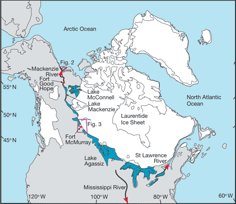
Broecker’s idea was that a massive glacial lake called Lake Agassiz could have drained to the east, down the St Lawrence and out into the Atlantic, but geologists have had trouble finding evidence for the size of flood that would have been required. It has been calculated that the lake lost around 9,500 cubic kilometres of water in the outburst. Now geological detective work by a team lead by Julian Murton of the University of Sussex has discovered evidence for a flood of the right size and the right time, but heading due north into the Arctic Ocean via the McKenzie River system [Science Daily, University of Sussex].

This map from Murton et al’s paper in a recent issue of Nature (Murton et al. Identification of Younger Dryas outburst flood path from Lake Agassiz to the Arctic Ocean. Nature (2010) vol. 464 (7289) pp. 740-743) shows the lie of the land at the time. The ice sheet was centred over Hudson’s Bay, and great lakes (some of them now Great) formed around its southern and western flanks as it melted. If you’re interested in this sort of geological and climatic detective work, it’s well worth reading the paper, but if you don’t have access this Nature News item gives a good overview of Murton et al’s work.
The great flood might be the most plausible mechanism for the trigger of the Younger Dryas cooling, but that hasn’t stopped other mechanisms being suggested. In recent years it has been proposed that a comet could have smashed into the Laurentide ice sheet causing catastrophic melting, but that idea hasn’t received much support from climatologists. The comet idea won’t lie down, however, and as Murton et al’s paper was hitting the presses, Professor Bill Napier of the University of Cardiff’s Astrobiology Centre was suggesting that the cooling could have been brought about by massive wildfires caused by the impacts of thousands of pieces of a cometary tail. The Daily Telegraph helpfully described it as “an hour long hailstorm from space“. For what it’s worth (which is not much), my money’s on the flood.

Grateful Dead – awesome! enuf said.
But the Mississippi flows the other way 🙂
Great article Gareth.
This kind of study really fascinates me.
I once saw a history channel program where they interviewed scientists who thought they had found evidence of a flood from the glacial region south into the Gulf of Mexico, but dammed if I am able to remember any of the names to reference on this blog.
Either way, such a flood could interfere with the Gulf Stream current and effect climate systems.
Thanks C3P0, it's the kind of thing that interests me too. There are three drainage routes for the lakes: south down the Missouri, northwest via the St Lawrence, and NE as suggested by this paper. The NW drainage cut the NIagara Falls, but it looks like the really dramatic outburst was to the NE. A similar outburst from Lake Missoula (which formed south of the smaller Cordilleran ice sheet) cut the famous channeled scablands in Washington State. Would have been an awesome sight…
It may have been the scablands that I was referring to (which would mean they didn't go into the Gulf of Mexico).
I wonder is similar events occurred in Eurasia and / or South America? So much we don’t know.
There were probably outbursts along the line of what is now the English Channel. IIRC there's research that links features on the sea bed to flood action, probably related to glacial lake collapses.
C3, Lake Missoula featured on the recent "The Power of the Planet" documentary series on Prime. Well worth a look.
http://www.bbc.co.uk/sn/tvradio/programmes/earthp…
Here are a couple of links to the Channel/La Manche stuff:
Physorg reporting French work.
The Guardian on a 2007 Nature paper…
If you've ever driven Interstate 80 across the U.S. west, you know that a large part of Iowa is very uniformly similar rolling hills, unlike the flat terrain I expected. Some years after my first such drive, I saw a TV show, where they talked about a huge ice dam bursting, at I believe the southern end of the Great Lakes. The rolling hills of Iowa were said to have been produced by the deluge. Like ripples in sand at the seashore, only bigger.
My recent post Climate Change and Disinformation