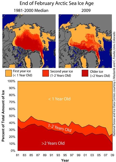
 As winter turns to spring and the melt season begins, the Arctic sea ice looks to be primed for another bad summer. Multi-year ice is down to only 10% of the total extent — down from 40% during 1979-2000, and new work on ice thickness suggests that the ice cover is thinner than at any point in the recent past. At a NASA/NSIDC press conference discussing the new data, UC Boulder scientist Walt Meier commented:
“We’re not set up well for summertime,” ice data center scientist Walt Meier said Monday. “We’re in a very precarious situation.” [Associated Press]
The NSIDC’s latest sea ice update reviews the past winter, and sets the scene for the coming summer. According to the latest data on sea ice age, the proportion of older ice (over 2 years old) has dropped to 10%, though the proportion of 1 – 2 year ice (ice from last winter that survived through summer 2008) has risen slightly.

(Animated gif of ice movements last winter here [1.1MB]).
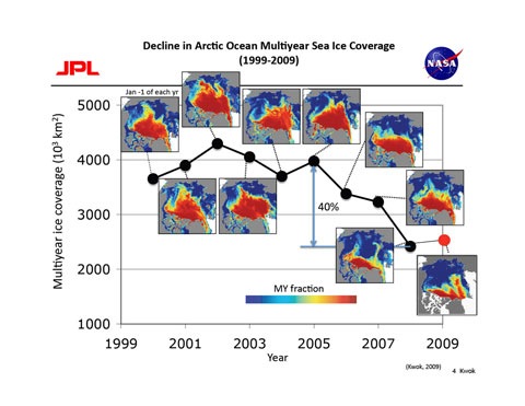
The decline in multi-year ice can also be seen in the data from NASA’s QuickScat satellite (click for larger image):
The reduction in multi-year ice is being matched by a general thinning of the sea ice cover. Last year, Ron Kwok at NASA’s Jet Propulsion Lab used to ICEsat data to show that sea ice had thinned from 2005 to 2006. Kwok’s team is now working to extend the data to cover 2003 – 2008. Here’s a visualisation of the sequence:
[youtube]3MVGsNkSp9U[/youtube]
This shows how the thick ice (white) is reduced to a narrow fringe north of Canada and around Greenland, while the thinnest ice (dark blue) increases in area as the years advance. Not much sign of any recovery there… I’ll resist speculating about the coming summer and the potential for new records until we’ve seen how the spring shapes up, but this early hint at the form suggests we’re in for another “interesting” year.

