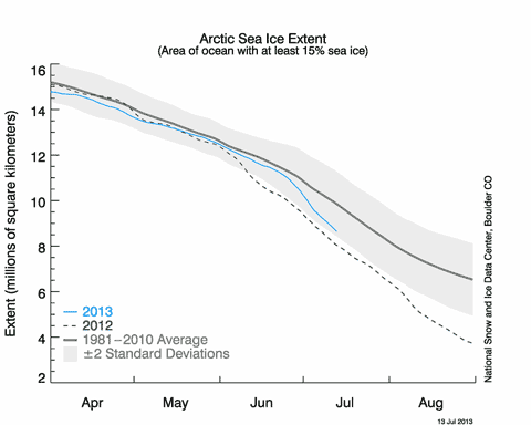
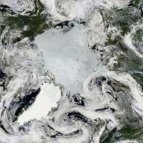
Looking down on the North Pole from satellite, NASA’s Arctic mosaic image for July 14 shows an unusually cloud-free view of the sea ice covering the Arctic Ocean. Click on the image to see the bigger original, and to zoom in on interesting regions. So far this year the sea ice melt has lagged behind last year’s record-setting performance, but in the last few weeks the rate of melt has increased significantly and the two years are moving closer together.

The NSIDC’s sea ice extent graph (above, for July 13) clearly shows the increase in melt, but there is still a substantial gap — over 0.5 million km2 — between the two years. This is, however, the time of year when the melt season goes into overdrive, with sunshine pouring energy into the Arctic 24 hours a day.
Weather has a big part to play in how the rest of the season will play out, and conditions favourable to rapid melting — such as the sort of cloudless skies we can see over the Beaufort Sea ((North of Canada/Alaska.)) — could see 2013 close the gap even further. Not possessing a crystal ball, I can only look at the long range forecasts issued by the European Centre for Medium-Range Weather Forecasts (ECMWF) and see what it suggests might happen.
The ECMWF publishes forecasts for up to two weeks ahead ((Click here, then click on the little map of Europe, then select “north hemisphere” from the left sidebar, and when the current pressure map is displayed, select a forecast map from the drop down menu.)). At the time of writing, these show the high pressure system bringing the cloudless skies over the Beaufort Sea declining slowly towards Canada, and by the end of the week a large cyclone (low pressure system) sets up in its place. In previous years, cloudy low pressure areas would have been expected to slow the melt, but a persistent cyclone earlier this year appears to have caused extensive fracturing of the ice — note the very broken up ice close to the Pole. A late season cyclone also contributed to 2012’s record ice loss.
The ice in the Beaufort Sea is certainly melting — the satellite image shows the ice surface tinged blue, a clear indication that surface melting is well under way. The NSIDC’s sea ice news for June noted:
…thin ice north of Alaska in the Beaufort and Chukchi seas, ranging from 1 to 1.5 meters (3 to 5 feet) in most areas and as low as 0.5 meters (approximately 2 feet) in others.
If the ECMWF forecast is correct and a cyclone develops over the Beaufort Sea next week, we could be looking at another period of extremely rapid ice melt. Will it be enough to enable 2013 to rival 2012? Far too early to tell ((For a more considered view, take a look at the July Report of the SEARCH September sea ice forecasting effort. Three teams are picking a new record…)), but this is the time of year when the state of the ice becomes really interesting to follow.
It might take a few months for the drama to unfold, but drama it most certainly is. The future of the planet is being written in the Arctic Ocean by the sun and the warming waters, and we get to watch.
[As ever, I strongly recommend following Neven’s Arctic Sea Ice Blog for the latest news and commentary on the progress of the melt season. Neven also maintains a very handy page of just about every graph and data source on the Arctic ice.]


One thought on “Arctic summer 2013: fragile ice pack feeling the pressure”