NZ emissions trading scheme announced

NzetsDetails of the government’s planned emissions trading scheme (ETS) have been announced. Scoop has all the government speeches and press releases. I’m reading them at the moment, and will comment more later, but here are some highlights:

  • Foresters will receive the full value of carbon credits on new growth (from 1/1/2008) in post-1990 forests.
  • Agriculture will not be brought into the scheme until 2013.
  • NZ emissions units will be Kyoto-complaint and internationally tradeable (subject to some limits).
  • Some units will be allocated free, others auctioned.
  • Forestry will be first into the scheme in Jan 2008.
  • Transport’s next, in 2009, basically through fuel prices
  • Stationery energy (power generation) and heavy industry will enter in 2010, with no free allocation for electricity generators.
  • Farmers will get free allocation of units based on 90% of 2005 emissions, but details to be worked out

The government hopes that 90% of power generation will be from renewable sources by 2025. In transport, they want to cut per capita emissions in half by 2040, and encourage the wide use of electric vehicles. Goals for agriculture are more nebulous: to be the world leader in emissions reduction research, and to lead the world in agricultural emissions reductions. In forestry, they would like a net increase of 250,000ha in forest area by 2020.
The government has also released an update on our expected Kyoto deficit – up to 45.5 millions tonnes from 41.2 mT, mainly from increased dairy production. In the absence of any emissions reduction policy, the government projects this could rise to 65mT, but believes the ETS will cut the 2008-12 deficit to 25mT.
My first thought? Politically astute. By getting foresters on board with what amounts to a taxpayer subsidy, they get enough trees planted to offset a large chunk of the Kyoto liability, and buy time to bring agricultural emitters in to the scheme. More later.

More ice/less ice

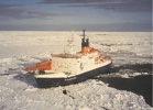
PolarsternMore on the Arctic melt: the National Snow and Ice Data Centre updates its commentary on this year’s record ice minimum. As of yesterday, the five day moving average of ice was still moving downwards, but slowly. Their comment on the North West Passage is interesting.

The main, deep channel of the Northwest Passage (Lancaster Sound to M’Clure Strait) has been open, or nearly ice-free, for about five weeks (since August 11, approximately). Of note is the northernmost ice edge ever recorded, at 85.5 degrees North, near the 160 degrees east longitude line.

Meanwhile, the RV Polarstern (see pic), near to completing a voyage through the Arctic as a contribution to International Polar Year, reports that large areas of this year’s ice have only been 1m thick – a 50% reduction on only 6 years ago. When the ship got close to the pole, it started raining. Ursula Schauer wrote (in early September):

A whole day of rain within 150 km of the North Pole came somewhat as a surprise! For the past few weeks, one low-pressure system after another has continuously carried warm air from northern Siberia (15°C at the Lena estuary!) towards the central Arctic Ocean. In this way the sea ice disintegrates more and more right before our eyes.

Meanwhile, I’ve bet Stoat (aka William Connolley) that 2008 will beat 2007’s record low. But only £10…

The not-so-lucky country

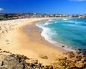
Australia-Bondi-BeachThe New South Wales government has decided that Sydney’s current water restricions are going to be permanent, because climate change projections suggest long term reductions in rainfall [Daily Telegraph(AU), ABC]. Meanwhile, CSIRO has released a report suggesting that three of the city’s great beaches could be lost to sea level rise. The Daily Telegraph reports:

[Waverley mayor George] Newhouse launched a climate-change marker today at North Bondi Children’s Pool, which he said was forecast to be under water by 2030. The marker indicates to beach visitors the predicted water height by 2100. “At Bondi, Tamarama and Bronte, we will just lose the whole beach and at other beaches like Collaroy and Narrabeen (in Sydney’s north) we will see houses falling into the water,

Arctic carries on melting

Ice070911Compare this picture with the one accompanying my last post on this season’s record-breaking sea-ice melt in the Arctic Ocean. More ice has gone, and although the end of the melt season is fast approaching, this year’s low is already about one million square kilometres less than the previous minimum, set in 2005. The NSIDC’s most recent report (Sept 10) also demonstrates that an area of ocean about the size of California is ice-free for the first time since satellite observations began in 1979. As the ocean cools, it will give up heat to the atmosphere. This could delay the onset of the northern hemisphere winter – and perhaps mean a repeat of last year’s mild NH autumn and the late arrival of winter. In turn, this sets up the Arctic for another year of record low ice in 2008, leading to suggestions that the Arctic could be ice-free in summer long before the IPCC expected. From The Guardian [UK]:

Continue reading “Arctic carries on melting”

Back in harness

ChinaI bought one of Martin’s pork pies today. After too much yak in Shangri-La, I found myself lusting after something a little more in my own cultural tradition… But as I try to catch up with climate news, I find that Xian Ge Li La is in the news for all the wrong reasons:

KUNMING, September 10 — One of China’s leading tourist landmarks, Meili Snow Mountain, will be devoid of snow within 80 years if global warming trends continue, a meteorological scientist warned on Monday. Liu Jiaxun also said China’s lowest and southernmost glacier, Mingyong, has shrunk by at least 40 meters over the past 13 years. The combined effects of ice melting and drying water sources would have devastating effects downstream, said Liu, deputy director of the Meteorological Bureau of Diqing Tibetan Autonomous Prefecture, in northeastern Yunnan Province. Mingyong — at 2,700 meters above sea level and 28.5 degrees north — had the lowest elevation and latitude of all China’s glaciers, said Liu. At 11.7 km long and covering 13 sq. km, it was shrinking faster than any other Chinese glacier, he said.

Sadly, during my visit to the Diqing Tibetan Autonomous Prefecture the Himalayas were shrouded in cloud. It rained. (Picture from Erhai Lake near Lijiang). Catching up will continue soon.

[Update: Pictures of the Meili Snow Mountain and glacier from China View here. The clouds cleared briefly, apparently…]