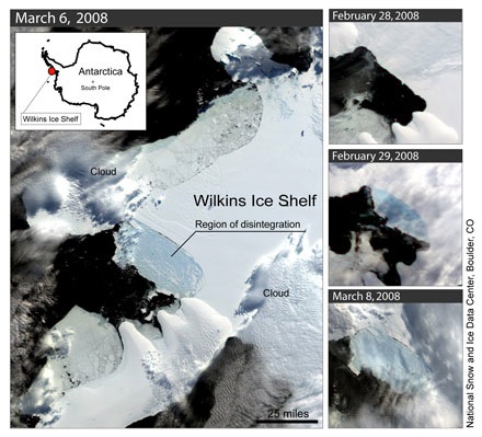
 Typical winter weather down here – we’ve gone from snow last weekend to sunny days and sharp frosts, and now howling Norwester and unseasonal, but not atypical warmth (having said that, the radio reports that Kaikoura recorded 21ºC at 1am last night, which is both). Further south, however, strange things are afoot at the Wilkins Ice Shelf. It began a spectacular break up earlier this year, and this is continuing in the middle of the Antarctic winter according to imagery from the European Space Agency’s Envisat. The ESA press release includes a fantastic animation showing how the ice has fractured over the last couple of months. Ted Scambos from the National Snow and Ice Data Center in the US explains how this might be caused:
“The persistently low sea ice cover in the area and data from some interesting sources, electronic seal hats [caps worn by seals that provide temperature, depth and position data] seems to suggest that warm water beneath the halocline may be reaching the underside of the Wilkins Ice Shelf and thinning it rapidly – and perhaps reaching the surface, or at least mixing with surface waters.”
I’d love to see a picture of those seal hats! And a scientist fitting one… I’ve heard some references to anomalous warm water around the Antarctic as a mechanism for ice sheet melting – here it seems to be in action.
Up North, the summer melt continues, and the odds on my bet with William “Stoat” Connolley seem to be tilting in favour of my vicious, sharp-toothed friend. Both the Cryosphere Today and NSIDC measures are showing area/extent tracking above the same time last year, and this week a team at the Alfred Wegener Institute provided a new form guide.
The ice cover in the Arctic Ocean at the end of summer 2008 will lie, with almost 100 per cent probability, below that of the year 2005 — the year with the second lowest sea ice extent ever measured. Chances of an equally low value as in the extreme conditions of the year 2007 lie around eight per cent.
They derive this by taking ice conditions at the end of June, feeding them into their sea ice model, and then forcing the model with the weather experienced over previous melt seasons. Looks pretty convincing, but any forecast is limited by the accuracy of the initial conditions data fed into the model. Still plenty of melt season left. It ain’t over ’til Dame Nellie finishes her peach Melba.
[Update: Wayne Davidson, in a comment at RealClimate, clearly thinks I’ve still got a chance.. 😉 ]
Finally, this will be an interesting blog to follow over the next few weeks. A team of US and Russian scientists are rafting down a Siberian river, gathering data on forests and tundra. Some people have all the fun…
[Update 2: It looks like the increased popularity of the AMSR-E sea ice images from Bremen has prompted Cryosphere Today to update their graphics for the Arctic. Positively groovey, perhaps even psychedelic, man. Way to go, Bill! Much easier to see what’s going on.]
[Update 3: The BBC reports on a Russian scientific team having to be rescued from their drifting research station because it’s melting fast.]


