Breakaway

Wilkinsbreaakup90408.gif

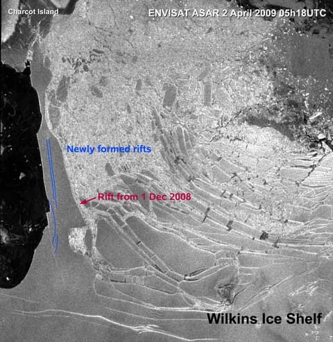
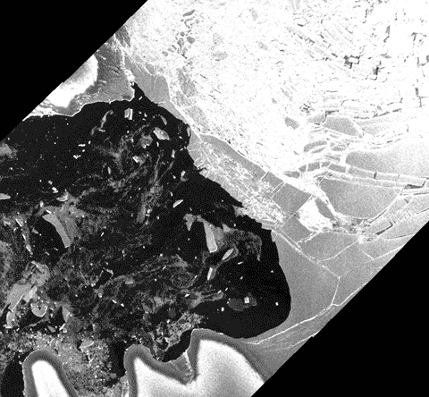
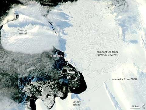
This somewhat crude(*), but effective animation of the two most recent ESA images of the Wilkins Ice Shelf break up shows clearly that with the “pin” gone, large areas of ice are beginning to move. The most recent image (April 8th) is the smaller, overlaid on one captured on April 5th. Focus on what was the narrowest part of the ice “bridge” to Charcot Island, and you can see a large berg rotating counterclockwise, while the mass of shattered ice at the original break up site and three big bergs to the east appear to be moving slowly north. To the NE of the base of the “bridge”, cracks are getting wider, while there’s also substantial northward movement in the big bergs to the north and east left by earlier collapses. It’s not clear from this pair of images what’s going on in the biggest cracks running SW/NE below the base of the “bridge”, but that will be the region to watch for the next big breaks.

[* What do you expect? GR fecit…]

Gone west

WilkinsNASA2009096.jpg

NASA’s Earth Observatory has just published a pair of beautiful images of the Wilkins Ice Shelf showing the ice bridge before and after collapse. The image above, acquired on April 6th, shows the bergs created by the break up moving towards the west. With the bridge gone, the remnant ice from earlier break ups to the east is now free to follow those bergs out to sea.

Melt away

NSIDC20090406thumb.jpg 
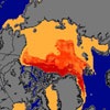
As winter turns to spring and the melt season begins, the Arctic sea ice looks to be primed for another bad summer. Multi-year ice is down to only 10% of the total extent — down from 40% during 1979-2000, and new work on ice thickness suggests that the ice cover is thinner than at any point in the recent past. At a NASA/NSIDC press conference discussing the new data, UC Boulder scientist Walt Meier commented:

“We’re not set up well for summertime,” ice data center scientist Walt Meier said Monday. “We’re in a very precarious situation.” [Associated Press]

Continue reading “Melt away”

…Gone

Wilkins0409breakup.jpg

Since I posted 12 hours ago on the imminent demise of a large chunk of the Wilkins ice shelf, new ESA imagery shows that it has finally collapsed into a shattered mass of icebergs — roughly centre of this image. The BBC has the story, together with comments from David Vaughan of the British Antarctic Survey. Loss of this “pin” could destabilise even more of the shelf — look at the large cracks bottom right…

[Update: see also Times Online, and the DomPost story has this quote from Prof Tim Naish of VUW’s Antarctic Research Centre: “It’s a consequence of global warming. Antarctica is behaving in a very strange way, bits of it are cooling and bits of it are warming. Our deep time records tell us that these ice shelves are the early warning signals; when they go, then we see quite dramatic and unstable changes in the ice sheets and glaciers feeding them.”

There have been a lot of new units of area invoked: Wilkins is as big as Connecticut, Jamaica, and almost half the size of Wales. But which half? Is Cardiff safe? 😉 ]

Last straw

Wilkins0409.jpg

The last bit of the ice “bridge” pinning the Wilkins Ice Shelf in place appears to be on the verge of collapse, according to the European Space Agency. New rifts formed on April 2nd (blue lines above), and have begun to spread rapidly. Worth keeping an eye on the ESA’s “webcam from space” over the next few days…

[Tip of the hat to Cindy in Bonn]

[Robert Wyatt]